The January Polar Vortex is showing signs of disruption far earlier than usual this winter, and meteorologists are paying close attention. What is usually a late-winter concern is now unfolding at the start of the year, catching both weather models and experts off guard. This shift is not just about timing; it is about intensity too. The strength of the current disturbance is raising eyebrows and prompting comparisons to some of the most dramatic vortex events in recent history.
In 2026, the January Polar Vortex is behaving differently. Instead of staying compact over the Arctic, it is weakening and wobbling, allowing frigid air to spill south. The early movement is setting the stage for potentially significant weather changes across the Northern Hemisphere. If you have noticed unusual cold snaps or are hearing chatter about strange weather patterns, you are not alone. Something rare is unfolding high above us.
What Makes the January Polar Vortex So Unusual in 2026?
This year’s January Polar Vortex event is not just happening earlier than usual; it is also one of the strongest early-season disruptions on record. The polar vortex, a massive pool of freezing air high above the Arctic, usually stays tightly wound until later in winter. But now, unusual warming in the stratosphere is pushing it out of place. That is sending cold Arctic air down to places where it is not expected, weeks ahead of schedule.
Scientists believe strong wave patterns from lower in the atmosphere are disrupting the vortex. This disturbance might even split the vortex into two, which can lead to even more chaotic weather. With jet streams likely to shift, parts of North America, Europe, and Asia could see intense cold, snow, and unpredictable patterns in the coming weeks. This is not a typical winter scenario, and experts are watching it closely.
Overview Table: What You Need to Know at a Glance
| Key Element | Details |
| Timing of disruption | Happening weeks earlier than expected |
| Usual behavior | Forms in autumn, weakens in late winter |
| Current behavior | Already stretching and weakening in early January |
| Cause of disruption | Strong wave activity pushing warm air upward |
| Altitude of impact | Around 30 kilometers above the Earth’s surface |
| Impact on jet stream | Could become wavy, allowing cold air to escape south |
| Regional effects | Possible extreme cold in some regions, milder in others |
| Comparison to past events | Similar to 2013 and 2018, but happening much earlier |
| Risk of vortex split | Some models show a potential split into two separate systems |
| Forecast reliability | Models agree it is unusual, but exact outcomes remain uncertain |
What is Happening with the January Polar Vortex?
Typically, the January Polar Vortex remains tight and stable in early winter, keeping cold air locked near the North Pole. But this season, it is losing its grip much earlier than expected. Rather than maintaining its circular form, it is starting to stretch and weaken. That means it can no longer contain Arctic air the way it usually does.
When this kind of disturbance happens early, it signals the possibility of prolonged cold snaps and extreme weather far from the Arctic. Weather forecasters are seeing patterns more common in February or even March. The earlier this shift happens, the longer it can influence global weather, making it a key concern for planners, governments, and anyone trying to stay warm this winter.
Why Scientists Are Uneasy About This December Shift
It is not just the timing of the January Polar Vortex shift that has experts talking. The level of pressure change and warming in the upper atmosphere is higher than usual for this time of year. These kinds of patterns typically show up later in the season, so when they appear around the holidays, it throws seasonal weather expectations into chaos.
Meteorologists are struggling to predict what comes next. Some models show the vortex may split in two, which would send cold air in opposite directions — possibly to Europe and parts of Asia. Others suggest it may simply drift away from the Arctic region. Both outcomes are rare for January and suggest that this winter may be very different from what we are used to.
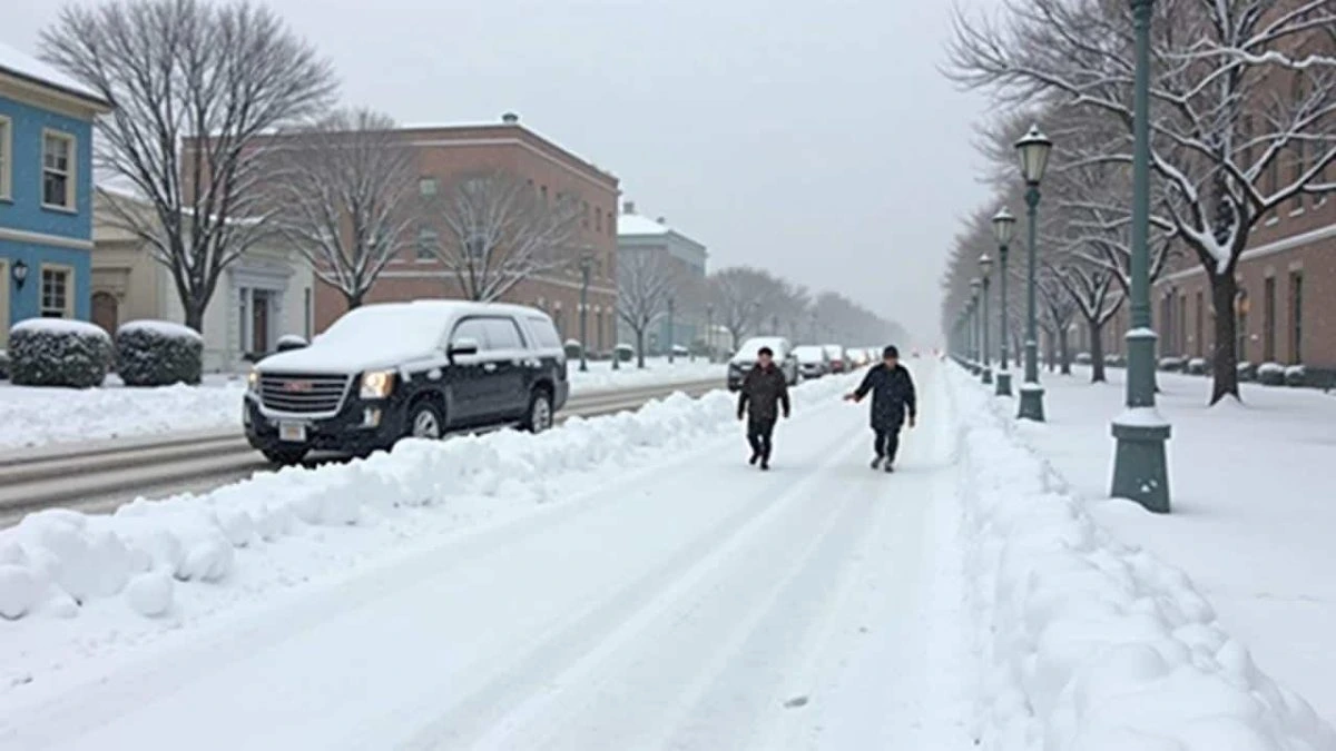
What a Disturbed Polar Vortex Actually Means on the Ground
The January Polar Vortex sounds like something that only matters to weather experts, but its effects are very real for people on the ground. When the vortex weakens, the jet stream becomes less stable. That creates big waves in the atmosphere that allow frigid Arctic air to move southward into places like the Midwest in the United States or Central Europe.
You might see sudden cold spells, freezing temperatures where they do not usually occur, or long-lasting snow events. In some cases, one region may be buried under snow while a nearby area experiences a dry and mild winter. These imbalances can disrupt travel, energy supply, and daily routines. For regions not used to deep winter weather, the impact can be more severe.
How Governments, Businesses, and Households Are Quietly Adjusting
With the January Polar Vortex already in motion, many sectors are quietly taking precautions. Energy companies are adjusting their usage forecasts to account for a potential spike in demand. Flight planners are watching the jet stream carefully since big shifts can lead to delays and cancellations.
Cities are checking snow removal budgets and crews earlier than normal. Households should be doing the same — checking heating systems, having backup supplies, and looking out for neighbors who may be vulnerable in sudden cold. The key is not panic, but preparation. The earlier the warning, the more time everyone has to get ready for potential disruptions.
Possible Surface Impacts from Atmospheric Changes
When the January Polar Vortex shifts, the surface weather reacts. These are some of the effects scientists are already preparing for:
- Weakened vortex: Cold Arctic air has a better chance of escaping into the mid-latitudes.
- Jet stream becomes wavy: This allows cold and warm air masses to mix in unpredictable ways.
- Blocking high-pressure systems: These can trap cold air in certain areas, causing longer cold spells.
- Unbalanced weather: Some places might face intense cold while others see unseasonal warmth.
- Travel delays: Snowstorms and icy roads may increase disruptions across multiple regions.
The Bigger Climate Question Hanging Over This Winter
One of the big conversations tied to the January Polar Vortex is whether these disruptions are becoming more common due to long-term climate shifts. Some researchers argue that warming oceans and reduced Arctic sea ice are adding extra energy to the system, fueling these early disruptions. Others believe it is too early to draw a direct link.
What everyone agrees on is that events like this one are happening more often than in past decades. Weather is becoming more unpredictable, and systems built around old seasonal expectations may not be as reliable today. Whether you believe climate change is driving it or not, the current winter pattern demands attention and awareness.
FAQs
What is the polar vortex?
The polar vortex is a large area of cold air in the stratosphere above the Arctic that usually stays contained in winter.
Is the January Polar Vortex dangerous?
It can be. When it weakens, it can bring extreme cold, storms, and weather that people are not prepared for.
Will it snow more because of the polar vortex?
Not everywhere, but some areas could see heavier snowfall if the cold air dips far enough south.
How long will this polar vortex disruption last?
The effects can last for weeks depending on how the vortex evolves and whether it splits or stabilizes.
Should people prepare now?
Yes. Simple steps like checking your heating, having extra food, and staying informed can make a big difference.